With my time at GCSU, I was fortunate enough to take two GIS classes (3100 and 4100) as well as a Remote Sensing class. Everyone that had taken GIS before that I had talked to said it was a very hard and challenging class. So with that engrained into my head, I was not looking forward to it. It was intimidating at first with Dr. Oetter speeding through lectures and labs and everyone having the "deer in the headlights" look, but I was determined to figure it out. It was hard remembering to reproject and set the correct data source, which led to a huge failure in the first exam, along with just learning the tools in ArcMap and ArcCatalog and getting the map just the way you like it and how it needs to be done. Pretty much Dr. Oetter threw us into the ocean with one water wing and expected us to survive. Luckily, I did.
Here is my second exam from 3100. This was actually the first exam, but since everyone kind of bombed the original, we were given a second chance a week later to redeem ourselves.
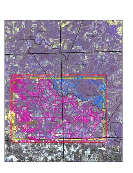
Like I said earlier, I was taken a Remote Sensing class along with my intro class to GIS. This class, I believe, helped me understand GIS a lot easier. Dr. Oetter also taught this class and it was the first time it was offered, so I was one of the pioneers of Remote Sensing at GCSU. The class had a total of 6 guys. I learned so much about the different types of satellites that have different types of sensors that only detect certain wave lengths and how each satellite can produce a different image of the same area. This image to the left is something that ended up being a whole semester long project. This is from the beginning stages where we had to obtain raster images of our home town and find a study area where we could drive around and plot points. With this study area, we then classified the vegetation based on what we thought it was using a classification system.
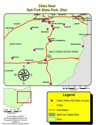
This map is from literally the first day of GIS 4100 which was an Advanced class. Dr. Oetter gave us the whole 2 hour class to create a map with no instructions except for what he wants the map to be of. After having a month off, I did not know if I would remember anything, but I surprised myself. We had to choose any state and then choose a state park within that state. After that we had to find which cities were within a certain distance, based on our discretion, and show the major roads around the park. I feel that I succeeded because look at that map! No one had a problem completing the task, but most of us had to dig up 3100 from our brains at the start.
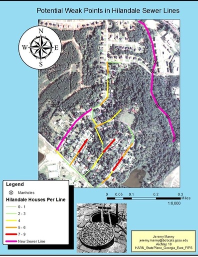
During 4100, we had to figure out what we wanted our semester project to be about. Unlike 3100, we had to work with another person or group and have outside assistance from somebody in Milledgeville. Since I was graduating in May 2013 and the fact that I needed an internship and had been applying to several county water authorities, I decided that I would focus on sewer lines in Milledgeville to better acclamate myself to the water authority world. I had to work with one other guy, but he was doing something totally different than what I had planned, but we had the same outside source, Mark Patrick, the city engineer for Milledgeville. I had planned to just map out the sewer lines, but that was already done so Mark asked me to map a new sewer line that had just been laid down using a GPS and GIS. I did that. But that was all he gave me to do and that was not enough for a semester's worth of work for a project. I then decided to look at a neighborhood that was just WSW of the line I had to map. I looked at how many houses were on three hundred feet of line and try to determine where a weak point could come up in the sewer line. The map to the right is what I came up with. Was it what I had intended? No, but it was something for me to learn about sewers.
