I decided in November of 2012 that for my senior capstone I would want to do an internship. I had never been a paper kind of guy so the next best option was an internship. I found out while taking 3100 that GIS is in almost every aspect of our world. It was the best choice for me so that I could see if GIS is really the career path I wanted to go down. So, I started sending my resumé out to a couple places that did nothing but GIS, but was shot down. It was not until my sister-in-law's birthday that I found out that water authorities also used GIS. My brother works for Douglas County Water Authority and he was telling me about how they use GIS and I was amazed. I put in for an internship position at his work in January thinking that since he was my brother that I would be perfect for the spot. I stopped sending my resumé out to places and waited to hear from them at anytime. Well April rolled around and nothing so just to keep my options opened I put my resumé out there a few more times and then Clayton County called asking for an interview. I nailed it and by May I had an internship at Clayton County Water Authority. Never thought I would be interning at CCWA, but I'm glad I did.
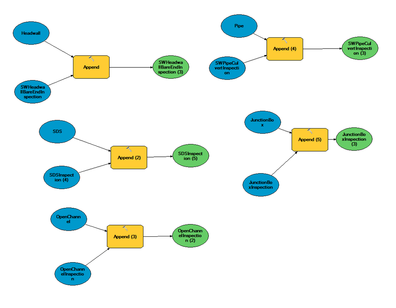
Going from what I was told by several people, I thought I would be just doing editing work and that's it. That was not the case. My supervisor, Bryan St. Mary, threw me back into that water like Dr. Oetter did with one water wing by giving me a task of creating a model for the Stormwater Inspections Contractor to use. I was in shock that they would give me something like that to do since I am just an intern, but I accepted the challenge. It was a tough week figuring out what to do and using every resource I could including my co-workers. In the end I was able to create two models that would be run together to create a tool for Stormwater Personnel to use.
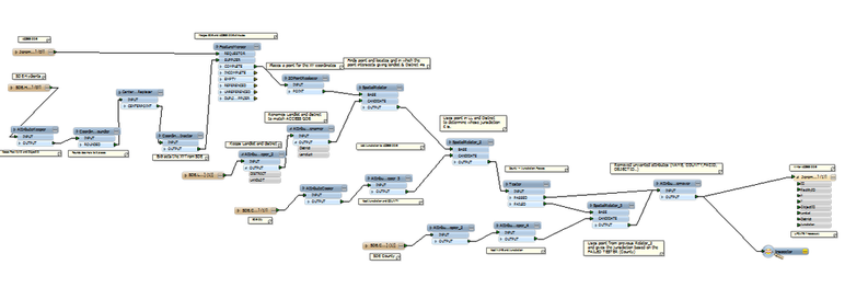
Oh, FME! This is another application that can combine multiple features from different sources and put them all into one same source. It was like model builder for the fact that it had tools and connectors, but it was a whole new ballgame. This frustrated me so much and I needed help just to get started, but I succeeded if that's what you want to call it. It was definitely something that I was glad to be exposed to because it does things that model builder just is not capable of doing. This particular model took information from a pre-existing Access database and combined it with features from and SDE database and put them together into a created Access table database with just the information that is needed. I am by no means an FME expert after doing this. It takes a while to get the hang of FME, but I look forward to using it again. There is more HERE about FME.

I have also been introduced to Cityworks while at CCWA. Cityworks is a web service that allows for both the use of GIS and managing infrastructure assets to be combined into one. A user can view where a work order, inspection, or service request is located based on the geocoded location on the map that is integrated with it. I used Cityworks mainly for inspections because I had to make sure what was in Cityworks matched what was in GIS. Below is a link to Cityworks home page.
